


Archaeologists across the world are setting aside their trowels to become drone pilots. No longer just a novel method of snapping photographs from the air, this evolving technology is now transforming how experts discover, monitor, and protect world heritage. In Peru, for example, a team has recently used drones to monitor nine archaeological sites, revealing how both natural hazards and human activities are impacting them over time. By flying over the same sites in the Barranca Valleys and recording them through photogrammetry—a method of creating 3D imagery—they have made a detailed record of degradation that will help to guide future preservation efforts.
Writing in the Journal of Field Archaeology, Edyta Puniach of AGH University of Krakow explained how she and her colleagues originally planned to time their flights with a mega-El Niño weather event. They expected that the heavy rainfall would give them the perfect chance to record its before-and-after impact on the Barranca Valleys’ heritage sites, including Huaricanga, a major administrative and ceremonial centre from around 3000BC. But when the extreme rains failed to materialise after their first drone flights in November 2023, the team used their aerial surveys to instead provide insights into how these sites fare during “ordinary” natural events and human activities: the movement of sand dunes, the impact of rivers and even illegal excavations.
Thankfully, once the team had completed their follow-up drone flights in July 2024, they did not identify any new evidence for looting pits, but their surveys did highlight the increasing dangers caused by the expansion of agricultural land and urbanisation, which impacted eight of the nine sites studied. Previously, these dangers would have been difficult to track, and might have gone unnoticed for a much longer period of time if not for these drone flights.
It is a sad reality that across the planet, archaeological sites are at risk. But with so many locations, and so little time and money, monitoring heritage from above—despite its obvious advantages—has always been a challenge; balloons, kites, planes and satellites have all played a role, but mainly for identifying sites, not saving them. Now, drones are giving archaeologists an edge. This method of “remote sensing” provides a bird’s-eye view of archaeological sites, and significantly, drone flights are easily repeatable at a low cost. The images produced are also increasingly detailed enough to spot even the tiniest changes on the ground. As the technology improves, experts will be able to feed this data into AI programmes trained to spot the tell-tale signs of emerging dangers, speeding the process further.
Climate change threatens Inuit sites
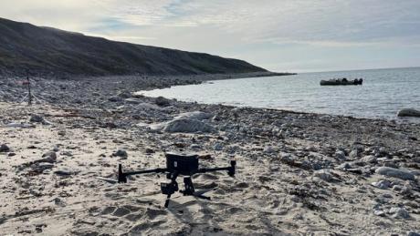
These developments will be particularly important in the ongoing battle to protect heritage sites from the effects of climate change. In July 2023 a team flew drones over seven archaeological sites in two different areas of Nunavik, a region in northern Quebec that has long been home to the Inuit. Their I. Indeed, according to the Arctic Monitoring and Assessment Programme, over recent decades the Arctic has been warming three times faster than the global average. Previously, pre-Inuit and Inuit archaeological sites remained relatively well protected, largely thanks to the freezing conditions, but this is no longer the case.
For the study, published in the Canadian Journal of Remote Sensing, Amedeo Sghinolfi of the Universités du Québec à Trois-Rivières and his colleagues used drones utilising a range of sensing techniques to test how effective these are at documenting sites endangered by erosion, vegetation growth and forest fires. With warmer temperatures, shrubs and trees are obscuring archaeological remains at some sites, while elsewhere forest fires are exposing them. Indeed, some of the vegetation is now so dense that even Lidar—a sensor usually capable of digitally stripping away forest canopies—had trouble viewing what lay beneath. This all highlights the urgency of such research.
Whether in Peru, Canada, or elsewhere in the world, heritage experts are facing difficult challenges.
Now, thanks to drone technology, they have a fast and low-cost way to see how endangered sites are changing—and hopefully where to step in before it is too late.